|
In the conic projection the graticule is projected onto a cone tangent, or secant, to the globe along any small circle (usually a mid-latitude parallel). In the normal aspect (which is oblique for conic projections), parallels are projected as concentric arcs of circles, and meridians are projected as straight lines radiating at uniform angular intervals from the apex of the flattened cone. Conic projections are not widely used in small scale mapping because of their relatively small zone of reasonable accuracy. The secant case, which produces two standard parallels, is more frequently used with conics. Even then, the scale of the map rapidly becomes distorted as distance from the correctly represented standard parallel increases. Because of this problem, conic projections are best suited for maps of mid-latitude regions, especially those elongated in an east- west direction. |
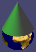
If you have a VRML-compatible browser installed on your computer, you may want to look at the following 3D virtual model of a cone, halfway between a globe and a conic projection. If you do not have a plugin capable of rendering Virtual Reality Models, you can download e.g. the Cosmo player or the Viscape player.
General characteristics
Ptolemy (in A.D.150) made no reference to a cone, but introduced two projections with concentric, circular arcs for parallels of latitude (like conics) but with meridians that are broken straight lines or circular arcs. These projections although conic-like, were not conic.
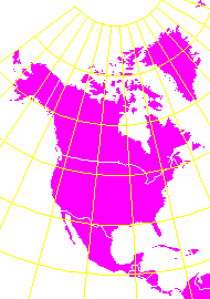 |
Equidistant or simple conic projection
|
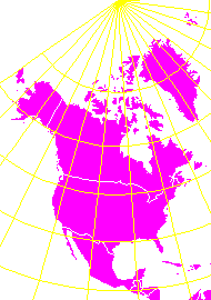 |
Lambert-Gauss conformal conic projection
|
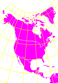 |
Albers equal-area conic projection
|
Suggestions are welcome
guszlev@ludens.elte.hu