| The term polyconic is generically applied to
any projection with circular arcs for parallels of latitude,
whether or not they are concentric |
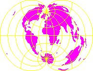 |
(Simple) Polyconic projection
- The projection is true to scale along the central meridian and
along each parallel. It is neither conformal nor equal-area, and it
is only free of distortion along the central meridian. Therefore,
it should only be used for regions of predominant north-south
extent
- The polyconic was applied as a specific projection in 1853 by
the US Coast Survey. It was commonly, but not exclusively, used for
coastal charts of the United States. The emphasis on usage by US
government agencies led to its use in several 19th century
commercial atlases as well, for some maps of the United States,
Canada, North America, Asia and Oceania.
The polyconic projection of Hassler is simultaneously universal for
a given figure of the earth (sphere or ellipsoid), simply drawn,
even for the ellipsoid, and employs useful scale
characteristics.
|
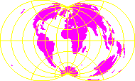 |
Rectangular polyconic projection
- Neither conformal nor equal-area
- The first reference to this projection was made in 1853. This
projection was derived and used at that time by the U.S. Coastal
Survey for portions of the United States exceeding about a square
degree. It has since been used for topographic maps of the British
War Office and thus has been called the War Office projection as
well.
|
 |
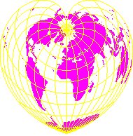
Bonne's pseudoconic projection
- Equal-area
- The Bonne was the preferred projection for atlas maps of large
countries and continents, giving the regions a uniform area scale
and an appealing combination of curved meridians and curved
parallels befitting a representation of the globe. More than half
the maps of the world's most populated continents were prepared on
the Bonne projections.
- The Bonne projection played a significant role in 19th century
larger-scale topographic mapping using ellipsoidal formulas. This
began with its adoption in France after efforts by Bonne in 1802,
when his projection was accepted by a special commission of the
Depot de la Guerre (war office). It later received the name
projection depot de la guerre in other European countries. These
regions included Austria-Hungary (1:750,000 scale maps), Belgium
(1:20,000 and reductions), Denmark (1:20,000), Italy (1:500,000),
Netherlands (1:25,000), Russia (1:126,000), Spain (1:200,000),
Switzerland (1:25,000 and 1:50,000), Scotland and Ireland (1:63,360
and smaller), as well as France (1:80,000 and 1:200,000) (Hinks
1912).
|
 |
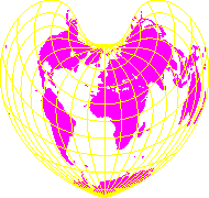
Werner (Stabius) pseudoconic projection
- Equal-area
- Heart-shaped (also referred to as cordiform and cardioid)
- In 1514, Stabius invented a series of three attractive
heart-shaped projections which were further publicized by
Werner.
- After sporadic usage, the cordiform projection all but
disappeared by the 18th century in favour of the Bonne projection.
This more general adaptation of Werner's projection provides less
angular distortion for a map of a continent.
|
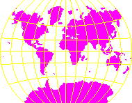 |
Van der Grinten projection
- Compromise, but huge distortion on high latitudes
- The whole Earth is represented on a circle
- Both paralles and meridians are circular arcs
|